Search
Results
Africa Map
mapping tool
________
________
TRAVIC - Transit Visualization Client
Halcyon Maps
earth wind map
Maps for the Web, made easy - CartoDB — CartoDB
The Racial Dot Map: One Dot Per Person for the Entire U.S.
The Racial Dot Map: One Dot Per Person for the Entire U.S.
Our Favorite Maps of 2013 - Emily Badger - The Atlantic Cities
[http://www.theatlanticcities.com/technology/2013/12/most-innovative-maps-2013/7952/] - - public:time
Maperitive
GeoCommons
Timelapse: Landsat Satellite Images of Climate Change, via Google Earth Engine
Maps Engine Lite
Maps and the City | Maps & Design
The Internet map
OpenStreetMap
Reykjavik Center Map
Wind Map
Maps » Ape Con Myth
Real-time local Twitter trends - Trendsmap
US road accident casualties across: every one mapped across America | News | guardian.co.uk
[http://www.guardian.co.uk/news/datablog/interactive/2011/nov/22/us-road-accident-casualties] - - public:time
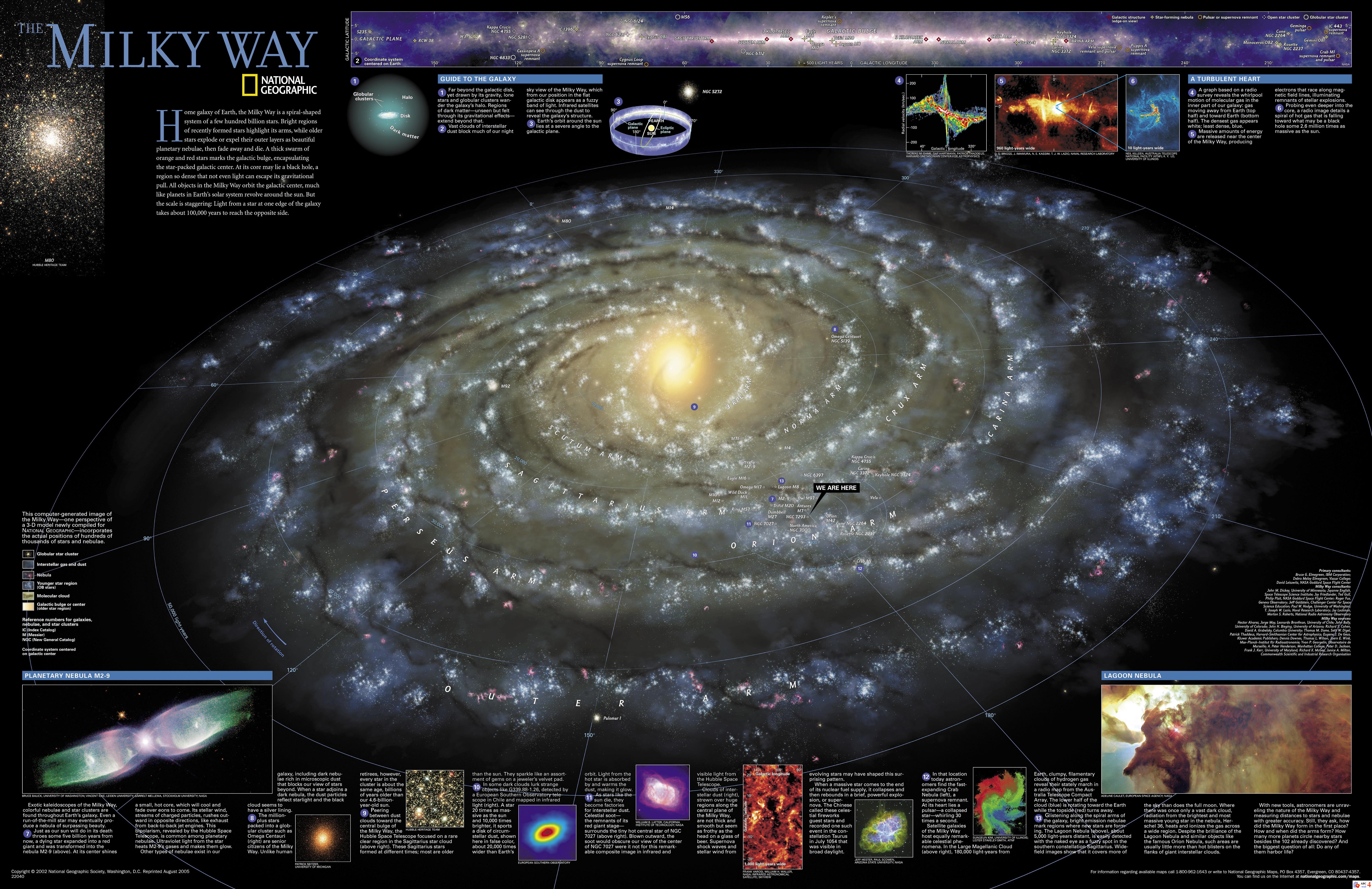
national-geographic-milky-way-reference-map1.jpg (JPEG Image, 6000x3887 pixels) - Scaled (16%)
[http://tzontonel.files.wordpress.com/2008/12/national-geographic-milky-way-reference-map1.jpg] - - public:time
Real-time Web Monitor
electoral college reform - fake is the new real
WeatherSpark | Interactive Weather Charts
Global distribution of the world's water
subways at scale
RSOE EDIS - Emergency and Disaster Information Service
GOOD »
Gene Expression: Personality variation by region (USA)
Map Projections
Chris Harrison's Visualization Projects
FiveThirtyEight.com: Electoral Projections Done Right
Hubble: Monitoring Internet Reachability in Real-Time
[http://hubble.cs.washington.edu/] - - public:time
Hubble: Monitoring Internet Reachability in Real-Time
ChurchBodies.gif (GIF Image, 886x643 pixels)
WIKISKY.ORG
GPS Visualizer
[http://www.gpsvisualizer.com/] - - public:time
GPS Visualizer is a free, easy-to-use online utility that creates maps and profiles from GPS data (tracks and waypoints), street addresses, or simple coordinates.